Historic Uptown Traffic Study
Dianne, of the Historic Uptown Neighborhood board, requested that the City of Colorado Springs conduct a traffic study since the neighborhood is experiencing a lot more traffic and safety concerns. The main goals of the study are to address traffic and pedestrian safety concerns, and speeding traffic.
Boundaries of the Study
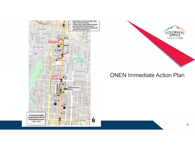
The City has told us they are studying: South of Uintah and north of Boulder. Looking at Weber, Wahsatch, Nevada, and Cascade in that space. Boundaries within our neighborhood are highlighted in red on the map below.
Reasons why the constraints south & north are:
- North of Uintah and Nevada is covered by a separate study Old North End Neighborhood is doing.
- South of Boulder is also covered by a separate study the Platte Avenue Study.
How Neighbors Can Help
The Historic Uptown Neighborhood Board’s role is to bring forward the neighborhood resident’s identified traffic concerns and partner with the City of Colorado Springs to identify solutions that will address the concerns.
Provide your Feedback
You can fill out our survey, email us, comment on this post, and message or comment on social media to share your identified traffic concerns with supporting information such as videos, pictures, and first-hand accounts.
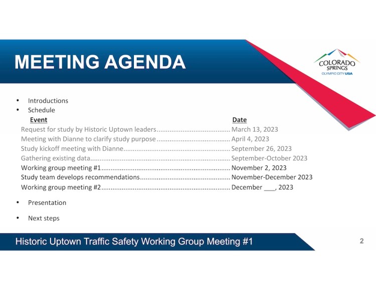
Meetings
Meeting dates can be found on our events calendar. Summaries of meetings between the City of Colorado Springs and the Historic Uptown Neighborhood Board can be found below.
March 8, 2024 Meeting
Cheryl, Dianne, and Jeff of Historic Uptown Board met with Traffic Engineering.
The purpose of the meeting was to:
- Review data analysis performed by the city on the crash data, traffic volume, and fatalities on the 4 main corridors.
- Discuss solutions proposed by the city to make the 4 main corridors safer and reduce traffic crashes. Data and Solutions Provided by the City can be reviewed in the Draft Memorandum below.
Key Highlights
- A comprehensive Traffic report/study was provided to Historic Uptown prior to the meeting.
- The report/study summarized traffic statistics and trends which were used to develop City recommendations on addressing traffic safety in the area. The meeting spent a good chunk of time reviewing the report and the resulting recommendations. See report for specifics.
- It was noted that after restriping Weber there was a significant drop in crashes. Traffic engineering relayed that typically there is a 40%-50% reduction in crashes when road dieting actions are put in place, such a stripping.
- It was noted that typically one can plan 1 car takes approx. 25 feet (this was noted during the discussion about parking a safe distance away from intersections to avoid blocking visibility.
- There was discussion about potentially “road dieting” Wahsatch. The process, would largely include ensuring the neighborhood wants it, conducting neighborhood outreach. It is also key to address such traffic issues at the right time with the City. Historic Uptown, Cheryl, stated she
would like the City to start the public process to make Wahsatch safer. Traffic Engineering, Todd, will give this consideration and discuss it with his leadership team. There was acknowledgement that both Cascade and Weber have benefitted from restriping/road-dieting. There was also discussion that this ask will need to be prioritized with others in the city. - Todd Frisbie and Karen Aspelin physically went to observe safety concerns at Platte/Wahsatch around the school. Traffic Engineering is still flushing out what changes, if any, to do at that location. There was further discussion about issues at other locations expressed by Historic Uptown: Weber & Cheyenne Ave, Boulder & Cheyenne Ave and Boulder & Weber. Traffic Engineering relayed they do school zones City-wide and that City wide there are higher priorities than Palmer and the surrounding area (there are 21 schools). Uptown asked if the crosswalks could be repainted. Traffic Engineering stated Platte/Wahsatch is biggest concern in the area.
- There was discussion about the report recommendations to restrict parking on Nevada avenue at the Dale, Monument, Willamette and St Vrain intersections. The report recommended 75 feet distance for all intersections. It was agreed that each intersection would be evaluated by Traffic Engineering and the appropriate distance decided (code at 30 ft, or 50 ft or 75 ft) to enhance safety while at the same time minimize parking impact to the businesses and residents. Uptown asked the City to reach out to CC and the businesses/neighbors to coordinate what would be done at each intersection.
- There was discussion that the remaining short-term traffic safety items would be worked by the City and placed on the list for City Traffic Technicians to work them. This includes the recommendations for Cascade, Nevada, Weber and Wahsatch. It was noted that the long-term roundabouts will continue to be evaluated.
- Historic Uptown is very appreciative of all the continued support from Traffic Engineering. The neighborhood is thankful for the comprehensive study and recommendations.
- Discussion on Historic Uptown Nameplates. Traffic Engineering showed three samples and provided an update on activities.
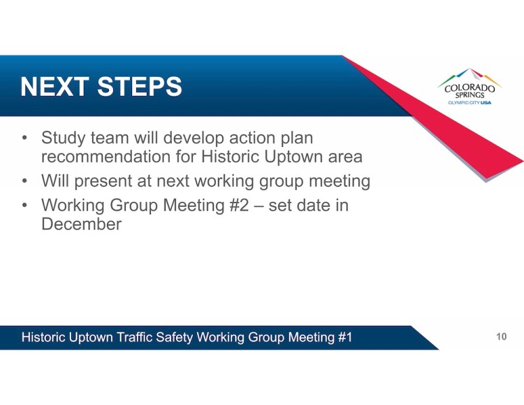
Next Steps
- City determine when to begin the pubic process on addressing traffic safety on Wahsatch “road dieting”.
- City determine what, if anything, will be done at Platte/Wahsatch for pedestrian school safety.
- City evaluate the parking distance restrictions at Dale, Monument, Willamette, St Vrain along Nevada to balance safety needs and business/residential parking needs.
- City continue the evaluation of the feasibility of roundabouts at Nevada Avenue/Platte Avenue and Willamette Street/Bijou Street.
- Historic Uptown send a thank you memo to Traffic Engineering
- Historic Uptown pick up the sample nameplates from the City CAB
To: Todd Frisbie, PE, PTOE
From: Colleen Guillotte, PE, PTOE, RSP 2I
Date: March 5, 2024
Re: Historic Uptown Speed Study and Safety Audit
Introduction
This study presents the results and findings of a speed study and safety audit of existing conditions for the neighborhood known as Historic Uptown. The neighborhood is bounded by Interstate 25 to the west, Wahsatch Avenue to the east, Bijou Street to the south, and Cache La Poudre Street to the north.
This study focuses on speeds, volumes, and crashes along the four primary north/south corridors within the neighborhood including Cascade Avenue, Nevada Avenue, Weber Street, and Wahsatch Avenue. The purpose of this study is to identify potential modifications to improve safety and reduce speeds. Some of the recommendations presented at the end of the report are small projects that City Traffic Engineering could fund using PPRTA dollars dedicated to intersection and roadway safety. As this is only a study, the capital improvements recommendations presented are unfunded and potential funding of any recommendations will need to be weighed against other needs across the City and available funding.
Each of the north/south corridors is approximately 0.68 miles long through the study section and each has a posted speed limit of 30 miles per hour (mph) except where noted below. The lane geometry and additional details are provided below for each corridor.
Cascade Avenue is a two-lane minor arterial with a bike lane, parking, and a raised median. The roadway was previously a four-lane roadway with no bike lanes. It was restriped in late 2018 to the current configuration. The roadway has a posted speed limit of 25 mph south of St Vrain Street.
Nevada Avenue is a four-lane principal arterial through study section. The roadway has a raised median and parking is allowed throughout the study segment on both sides of the roadway. The roadway has a posted speed limit of 25 mph south of Boulder Street.
Weber Street is a two-lane minor arterial with a bike lane, parking, and a two-way left-turn. The roadway was previously a four-lane roadway with no bike lanes or turn lanes. It was restriped in 2020 to the current configuration.
Wahsatch Avenue is a four-lane minor arterial through most of the study section. The segment south of Boulder Street is a principal arterial. The roadway has a raised median and parking is allowed throughout the study segment on both sides of the roadway.
Traffic Analysis
Traffic Volumes
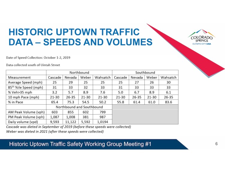
Weekday daily traffic volume and speed data was collected in using Streetlight data at three locations:
- South of Uintah Street
- South of Dale Street
- South of Boulder Street
The location south of Uintah Street is not within the study area, but the location was included because many historic counts have been recorded at this location. Table 1 provides the resulting daily traffic volumes on the four corridors.
Table 1 – Weekday Traffic Volumes
| Count Location | Weekday Volume | |||
| Cascade | Nevada | Weber | Wahsatch | |
| South of Uintah | 8,700 | 14,900 | 5,700 | 10,000 |
| South of Dale | 7,300 | 13,400 | 5,700 | 8,300 |
| South of Boulder | 9,500 | 14,700 | 6,200 | 10,700 |
As shown, Nevada Avenue carries the highest volumes of the north/south roadways. This is consistent with expected usage of the roadway. Of the four corridors, Nevada Avenue is the longest corridor, and it provides access to I-25 both north and south of downtown. The other corridors provide access to downtown, but they do not continue south to I-25 or north to University Village and beyond. Weber Street and Wahsatch Avenue end a few blocks north of Jackson Street, while Cascade only provides local access north of Fillmore Street.
Alternative north/south corridors that parallel Nevada Avenue that provide equivalent access to roadways to the north and south would be I-25 located approximately 0.6 miles west of Nevada Avenue and Union Boulevard located approximately 1.4 miles east of Nevada Avenue.
Hourly Volumes
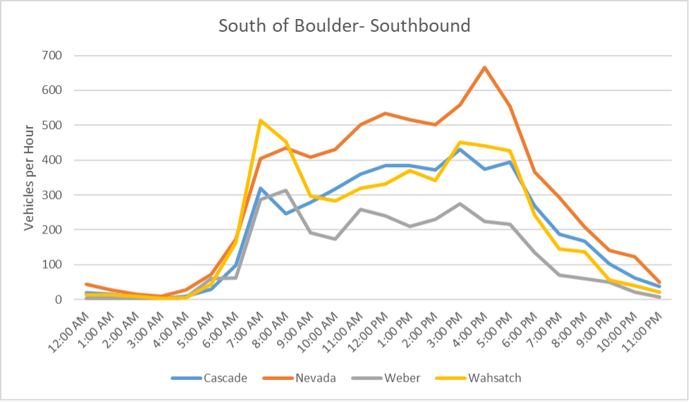
Hourly volumes of all four corridors were plotted by direction for the count locations south of Dale Street and south of Boulder Street. Figures 1 and 2 provide the hourly volumes for the corridors south of Dale Street for the northbound and southbound directions, respectively. Likewise, Figures 3 and 4 provide the hourly volumes for the corridors south of Boulder Street for the northbound and southbound directions, respectively.
As shown, Nevada Avenue carries the highest peak hour volume of the four corridors followed by Wahsatch Avenue. In the northbound direction all the corridors peak in the afternoon, while in the southbound direction Wahsatch Avenue has a large morning peak.
Figure 1: Northbound Hourly Volumes – South of Dale
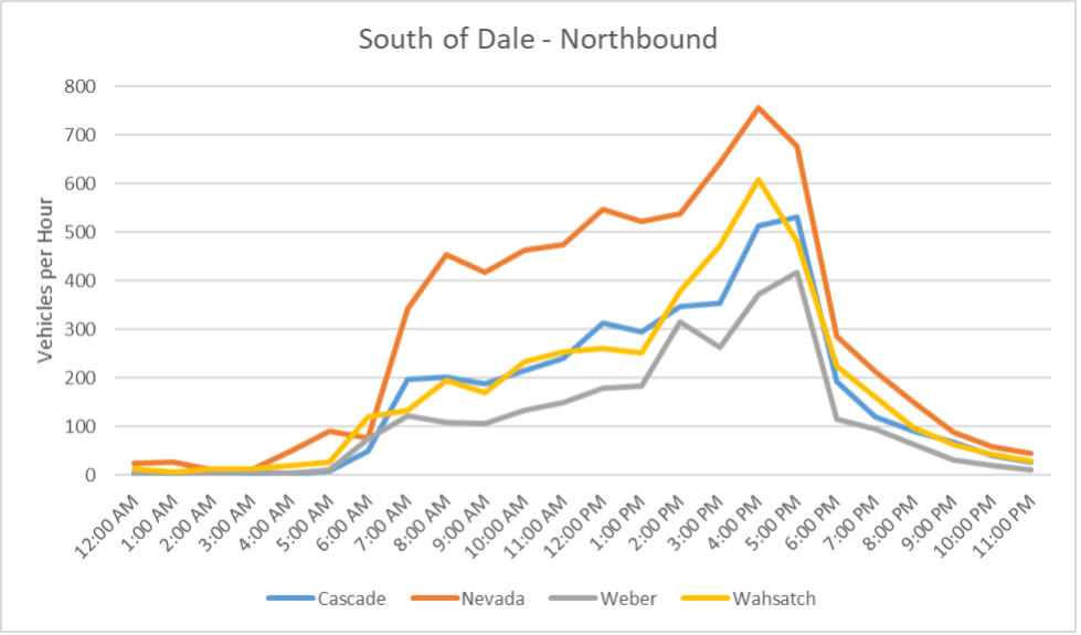
Figure 2: Southbound Hourly Volumes– South of Dale
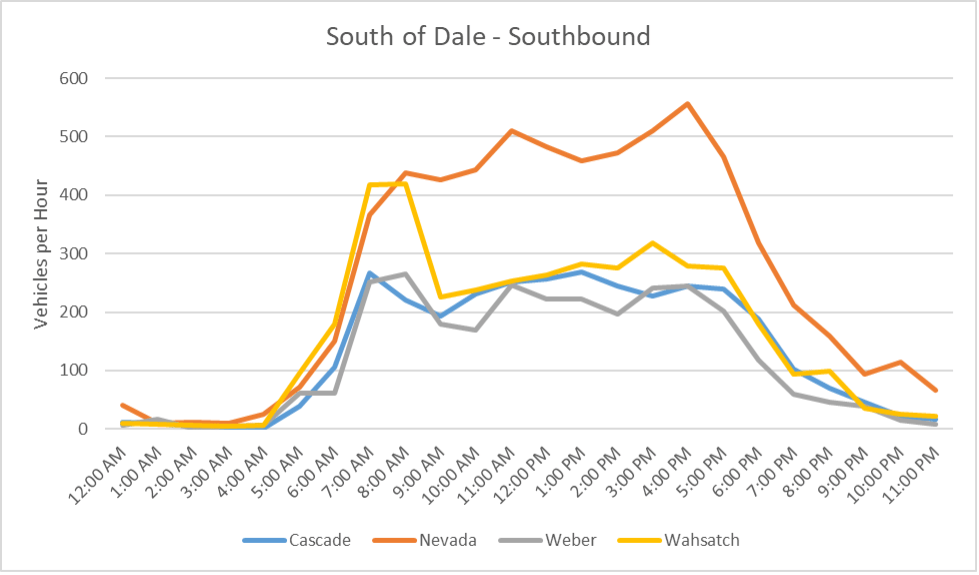
Figure 3: Northbound Hourly Volumes – South of Boulder
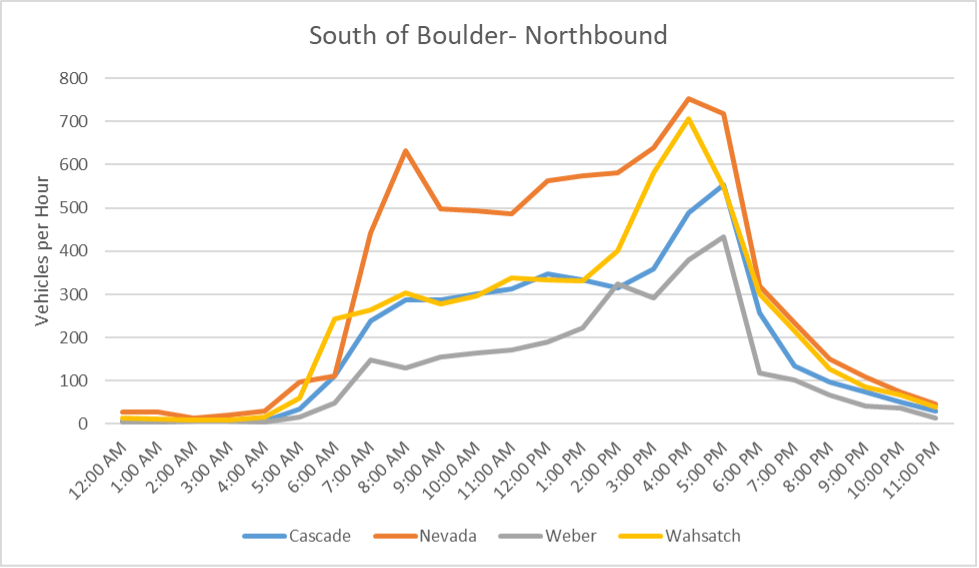
Figure 4: Southbound Hourly Volumes– South of Boulder
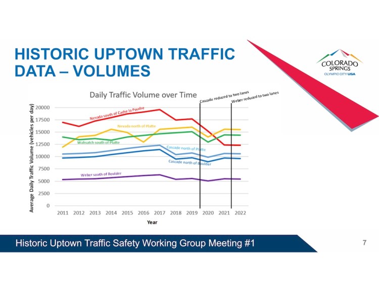
Historic Volumes
Several roadway improvements have been completed between 2000 and today that may have affected traffic volumes on the roadways in the study area. These improvements and their approximate dates include:
- 2006 – The north Nevada Avenue / I-25 ramps were reconfigured.
- The previous ramp alignment had a southbound off-ramp on the left side of the interstate that led directly to southbound Nevada Avenue.
- Likewise, northbound Nevada Avenue merged directly on to northbound I-25.
- The reconfiguration made Nevada Avenue less of an easy bypass route and reduced overall traffic on Nevada Avenue.
- 2015 – The Fillmore Street / I-25 ramps were reconfigured to relieve congestion.
- The reconfiguration reduced congested and opened up I-25 as a route for vehicles that may have been using Nevada Avenue or parallel routes to avoid the congestion at the interchange.
- 2018 – As a traffic calming effort, Cascade Avenue was restriped as a two-lane roadway with bike lanes. Additionally, all four roadways in the Old North End had the posted speed limit reduced from 35 miles per hour (mph) to 30 mph.
- 2021 – Another traffic calming effort that had Weber Street restriped as a two-lane roadway with bike lanes.
The historic roadway volumes and the impacts of the listed improvements will be looked at for the roadways in the next section of the report.
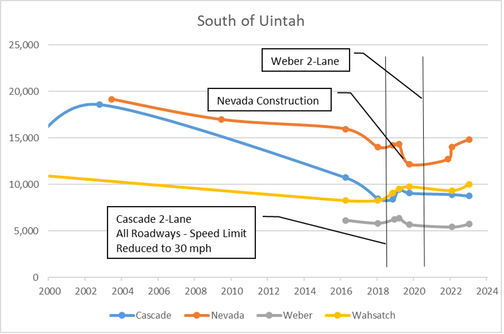
South of Uintah Street
Current count data was compared against past count data. Historic counts were typically collected between Cache La Poudre Street and Uintah Street. Although this is north of the study area, the same location was chosen in Streetlight to be consistent. Figure 5 provides historical weekday count data going back to the year 2000 for the segment south of Uintah Street.
As shown in Figure 5, volumes on Nevada Avenue have dropped to 14,900 vpd in 2022. This represents a 22 percent decrease over a 20-year period. The ramp reconfigurations of Nevada Avenue/I-25 and Fillmore Street/I-25 both appear to have had an impact on the volumes on Nevada Avenue and Cascade Avenue.
The chart has notations indicating when the improvements to the roadways were completed. Nevada Avenue saw a slight increase in traffic after Cascade Avenue was restriped as a two-lane roadway. Additionally, Nevada Avenue was under construction in late 2019 and was reduced to one lane in each direction. Some traffic was diverted to parallel streets during the lane closure.
Figure 5: Historical Weekday Volumes – South of Uintah
Speed
Vehicle speeds were recorded by direction at the count locations using Streetlight data. The posted speed limit is 30 miles per hour on all four of the corridors in the study area except where noted in the tables. Tables 2 and 3 provide the 85th percentile speeds for the data collection locations for the northbound and southbound directions, respectively.
Table 2 – 85th Percentile Speed – Northbound
| Count Location | 85th Percentile Speed (mph) | |||
| Cascade | Nevada | Weber | Wahsatch | |
| South of Uintah | 32 | 35 | 33 | 31 |
| South of Dale | 37 | 39 | 37 | 41 |
| South of Boulder | 35* | 36* | 35 | 36 |
Table 3 – 85th Percentile Speed – Southbound
| Count Location | 85th Percentile Speed (mph) | |||
| Cascade | Nevada | Weber | Wahsatch | |
| South of Uintah | 33 | 36 | 35 | 36 |
| South of Dale | 37 | 39 | 37 | 41 |
| South of Boulder | 33* | 35* | 34 | 36 |
As shown, the 85th percentile speeds are between two and nine miles per hour over the posted speed limit except where highlighted on the tables. Wahsatch Avenue has speeds exceeding the speed limit by 11 mph. Cascade Avenue and Nevada Avenue both exceed the speed limit by up to 11 mph south of Boulder Street where the limit is posted at 25 mph. This indicates speeding is an issue at some locations on these corridors.
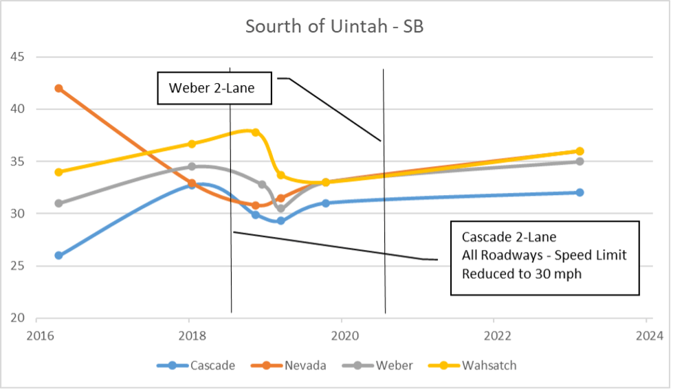
Historic Speed
The City began collecting speed count data in 2016 on the north/south roadways south of Uintah Street. Figures 6 and 7 provide the 85th percentile speeds on all four roadways for the northbound and southbound directions, respectively. All figures have notations indicating when restriping and speed limit improvements occurred on the corridors.
It is difficult to identify impacts of roadway changes due to construction that occurred on Nevada Avenue in 2019 that had a significant impact on speeds on all four corridors, especially in the northbound direction.
Figure 6: 85th Percentile Speed – South of Uintah – Northbound
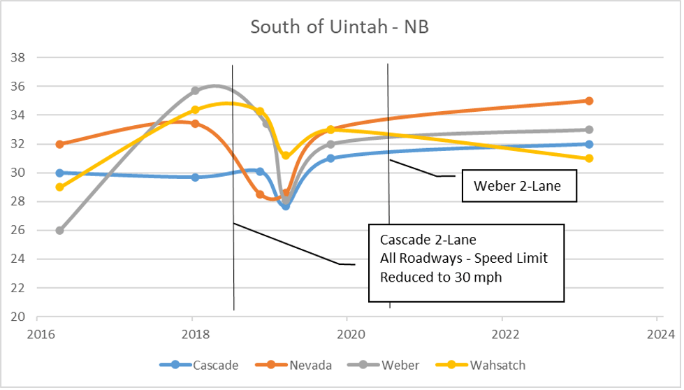
Figure 7: 85th Percentile Speed – South of Uintah – Southbound
Safety Analysis Summary
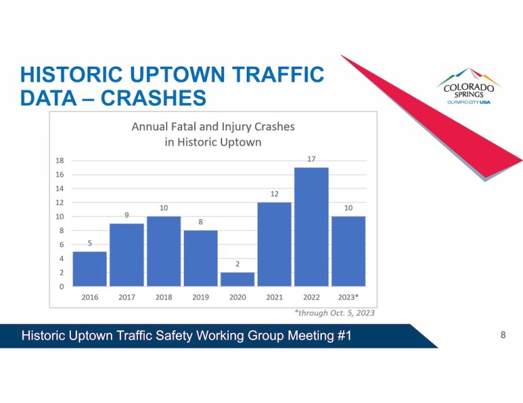
Five years of crash history (1/1/2018 – 12/31/2022) was examined to locate crash clusters and identify countermeasures on the four study corridors. For this analysis only crashes occurring on the four study corridors or at intersections with the study corridors were included. This section discusses high-level patterns over the study corridors. The corridors will be analyzed separately later within this memo for specific recommendations.
During the five-year study period, 83 crashes were reported on Cascade Avenue, 203 on Nevada Avenue, 166 on Weber Street, and 110 on Wahsatch Avenue. Table 4 summarizes the crash history of these corridors over the study period. The crashes are broken down by location (intersection, non-intersection, and driveway) in Table 5. As shown, most crashes occurred at intersections on each corridor while driveway crashes only make up approximately one percent of total crashes.
It should be noted that the traffic volumes significantly dropped after mid-March 2020 due to the COVID-19 pandemic, which would have impacted the number of crashes.
Intersection Crash Analysis
Intersections in the corridors were analyzed using level of Service of Safety (LOSS) through the use of Safety Performance Functions (SPF). LOSS uses qualitative measures that characterize safety of an intersection in reference to its expected performance. If the level of safety predicted by the SPF will represent a normal or expected number of crashes at a specific level of ADT, selected percentiles within the frequency distribution can be stratified to represent specific levels of safety.
- LOSS I – Below 20th Percentile
Indicates a low potential for crash reduction.
- LOSS II – 20th Percentile to Mean
Indicates a low to moderate potential for crash reduction.
- LOSS III – Mean to 80th Percentile
Indicates a moderate to high potential for crash reduction.
- LOSS IV – Above 80th Percentile
Indicates a high potential for crash reductions.
LOSS reflects how the roadway or intersection is performing in regard to its expected crash frequency at a specific level of traffic volumes on both the major and minor street. It only provides a crash frequency and severity comparison with the expected norm. It does not, however, provide any information related to the nature of the safety problem itself. If a safety problem is present, LOSS will only describe its magnitude from the frequency and severity standpoints. The nature of the problem is determined through diagnostic analysis techniques.
Intersection related crashes on the study corridors within the study limit were examined and reviewed using this SPF analysis.
Crashes that can be attributed to intersections accounted for approximately 85 percent of the crashes along the corridor. Table 6 provides the number of crashes at each of the study intersections by severity, while Table 7 provides the resulting level of service of safety for total crashes and severe crashes by intersection.
Table 4 – Corridor Crash History by Year
| Year | Cascade | Nevada | Weber | Wahsatch | ||||||||||||
| PDO | Injury | Fatal | Total | PDO | Injury | Fatal | Total | PDO | Injury | Fatal | Total | PDO | Injury | Fatal | Total | |
| 2018 | 19 | 3 | – | 22 | 41 | 7 | – | 48 | 17 | 11 | 1 | 29 | 26 | 14 | – | 40 |
| 2019 | 17 | 4 | – | 21 | 30 | 18 | – | 48 | 15 | 13 | – | 28 | 25 | 9 | – | 34 |
| 2020 | 5 | 3 | – | 8 | 13 | 15 | 1 | 29 | 8 | 5 | – | 13 | 10 | 12 | – | 22 |
| 2021 | 8 | 6 | – | 14 | 17 | 13 | – | 30 | 14 | 6 | – | 20 | 25 | 7 | – | 32 |
| 2022 | 11 | 7 | – | 18 | 32 | 15 | 1 | 48 | 12 | 8 | – | 20 | 25 | 13 | – | 38 |
| Total | 60 | 23 | 0 | 83 | 133 | 68 | 2 | 203 | 66 | 43 | 1 | 110 | 111 | 55 | 0 | 166 |
| Ave/Yr | 12 | 4.6 | 0 | 16.6 | 26.6 | 13.6 | 0.4 | 40.6 | 13.2 | 8.6 | 0.2 | 22 | 22.2 | 11 | 0 | 33.2 |
Table 5 – Corridor Crash History by Location
| Location | Cascade | Nevada | Weber | Wahsatch | ||||||||||||
| PDO | Injury | Fatal | Total | PDO | Injury | Fatal | Total | PDO | Injury | Fatal | Total | PDO | Injury | Fatal | Total | |
| Intersection | 45 | 20 | – | 65 | 111 | 62 | 2 | 175 | 49 | 40 | – | 89 | 95 | 51 | – | 146 |
| Non-Intersection | 12 | 3 | – | 15 | 22 | 6 | – | 28 | 15 | 2 | 1 | 18 | 15 | 4 | – | 19 |
| Driveway | 3 | – | – | 3 | – | – | – | – | 2 | 1 | – | 3 | 1 | – | – | 1 |
| Total | 60 | 23 | 0 | 83 | 133 | 68 | 2 | 203 | 66 | 43 | 1 | 110 | 111 | 55 | 0 | 166 |
Table 6 – Intersection Crashes
| Intersecting Street | Cascade | Nevada | Weber | Wahsatch | ||||||||||||
| PDO | Injury | Fatal | Total | PDO | Injury | Fatal | Total | PDO | Injury | Fatal | Total | PDO | Injury | Fatal | Total | |
| Cache La Poudre St | 8 | 1 | – | 9 | 10 | 8 | – | 18 | 5 | 7 | – | 12 | 7 | 7 | – | 14 |
| Dale St | 1 | – | – | 1 | 7 | 5 | – | 12 | 2 | 1 | – | 3 | 4 | 5 | – | 9 |
| Monument St | 1 | 2 | – | 3 | 10 | 5 | – | 15 | 1 | 1 | – | 2 | 4 | 4 | – | 8 |
| Willamette St | – | 1 | – | 1 | 8 | 3 | 1 | 12 | 9 | 7 | – | 16 | 13 | 3 | – | 16 |
| St Vrain St | 1 | – | – | 1 | 6 | – | – | 6 | 4 | 1 | – | 5 | 2 | 2 | – | 4 |
| Boulder St | 2 | 3 | – | 5 | 13 | 7 | – | 20 | 17 | 11 | – | 28 | 6 | 6 | – | 12 |
| Platte Ave | 10 | 2 | – | 12 | 43 | 22 | 1 | 66 | 39 | 15 | – | 54 | 10 | 11 | – | 21 |
| Bijou St | 22 | 11 | – | 33 | 14 | 12 | – | 26 | 18 | 8 | – | 26 | 3 | 2 | – | 5 |
| Total | 45 | 20 | 0 | 65 | 111 | 62 | 2 | 175 | 95 | 51 | 0 | 146 | 49 | 40 | 0 | 89 |
Table 7 – Intersection Levels of Service of Safety
| Intersecting Street | Cascade | Nevada | Weber | Wahsatch | ||||
| Total | Severe | Total | Severe | Total | Severe | Total | Severe | |
| Cache La Poudre St | III | II | III | IV | IV | IV | III | IV |
| Dale St | II | II | IV | IV | IV | IV | III | III |
| Monument St | III | III | IV | IV | IV | IV | II | III |
| Willamette St | II | II/III | IV | IV | IV | IV | IV | IV |
| St Vrain St | II | II | III | II | IV | III/IV | IV | III |
| Boulder St | I/II | II/III | II | III | III | IV | III | IV |
| Platte Ave | I | I | IV | IV | III | III | III | III |
| Bijou St | III | III | II | IV | III | III | IV | IV |
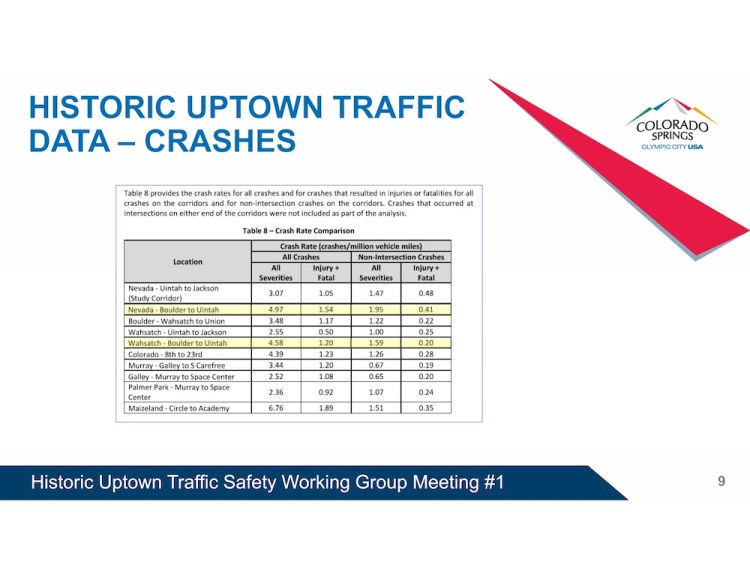
These intersections were also tested for the presence of patterns related to crash type, severity, direction of travel, road conditions, spatial distribution of crashes, time of day, and behavioral attributes. Table 8 provides any crash patterns that were identified. The intersections will be evaluated in the corridor sections that follow.
Table 8 – Intersection Crash Patterns
| Intersecting Street | Cascade | Nevada | Weber | Wahsatch |
| Cache La Poudre St | Rear-ends | – | Broadside | Broadside |
| Dale St | – | Broadside | – | – |
| Monument St | – | – | Broadside | – |
| Willamette St | – | – | Broadside | Broadside |
| St Vrain St | – | Broadside | – | – |
| Boulder St | – | Broadside | – | Broadside |
| Platte Ave | – | Approach Turn | Broadside | Approach Turn Sideswipe – Same Direction |
| Bijou St | Broadsides Sideswipe – Same Direction | Approach Turn | – | Broadside |
Non-Intersection Crash Analysis
Non-intersection crashes account for 14 percent of all crashes observed on the study corridors. Table 9 provides a breakdown of non-intersection crashes by type on each corridor. As shown parked motor vehicle crashes are predominant followed by rear-end and sideswipe same direction type crashes. Parked motor vehicle, fixed object, and sideswipe same direction type crashes are all due to vehicles leaving their lane of travel. Rear end and sideswipe crashes are typically the results of congestion.
Driveway Analysis
Driveway crashes account for1 percent of all crashes (7 of 562) observed on the study corridors. No crash patterns were identified.
Table 9 – Non-Intersection Crashes by Type
| Crash Type | Cascade | Nevada | Weber | Wahsatch | ||||||||||||
| PDO | Injury | Fatal | Total | PDO | Injury | Fatal | Total | PDO | Injury | Fatal | Total | PDO | Injury | Fatal | Total | |
| Parked Motor Vehicles | 3 | 1 | – | 4 | 10 | 1 | – | 11 | 5 | – | – | 5 | 9 | 4 | – | 13 |
| Rear-End | 7 | 1 | – | 8 | 5 | 2 | – | 7 | 1 | 1 | – | 2 | 3 | – | – | 3 |
| Sideswipe Same Direction | 1 | – | – | 1 | 6 | 2 | – | 8 | 9 | – | – | 9 | 2 | – | – | 2 |
| Fixed Object | 1 | – | – | 1 | 1 | 1 | – | 2 | – | – | – | 0 | 1 | – | – | 1 |
| Pedestrian | – | 1 | – | 1 | – | – | – | 0 | – | 1 | – | 1 | – | – | – | 0 |
| Bike | – | – | – | 0 | – | – | – | 0 | – | – | 1 | 1 | – | – | – | 0 |
| Total | 12 | 3 | 0 | 15 | 22 | 6 | 0 | 28 | 15 | 2 | 1 | 18 | 15 | 4 | 0 | 19 |
Cascade Avenue – Safety
Signalized Intersections
Cascade Ave / Bijou St
Classification: 2-Lane Divided Signalized 4-leg Intersection
ADT: Primary – 12,000 vpd (Cascade); Secondary – 8,750 vpd (Bijou)
Total Crashes: 33 (11 injury crashes)
LOSS: III (all crashes); III (injury & fatal crashes)
Crash Pattern: Broadside, Sideswipe Same Direction
Broadside Crash Analysis
Total Crashes: 11 (5 injury crashes)
Causal Factor: Nine of the crashes were the fault of southbound running a red light.
Recommendation: Install backplates on all approaches. Review signal progression southbound on Cascade Avenue.
Sideswipe Same Direction Crash Analysis
Total Crashes: 8 (0 injury crashes)
Causal Factor: Five crashes involved westbound vehicles; the remaining were northbound vehicles. Several of these crashes occurred during construction that blocked Bijou laneage. Additionally, Cascade was restriped in late 2018 and several crashes occurred before the restriping.
Recommendation: Continue to monitor this intersection. Consider adding westbound lane striping through the intersection if westbound crashes continue.
Non-Intersection
There are no recommendations for non-intersection improvements.
Nevada Avenue – Safety
Cascade Avenue experienced 15 non-intersection crashes of which 8 were rear-ends and 4 were parked vehicles. There were no identified patterns regarding the location of the rear-ends or parked vehicle crashes across the corridor. The number of non-intersection crashes has dropped since the corridor was restriped as a two-lane roadway.
Signalized Intersections
Nevada Ave / Boulder St
Classification: 4-Lane Divided Signalized 4-leg Intersection
ADT: Primary – 14,150 vpd (Nevada); Secondary – 4,750 vpd (Boulder)
Total Crashes: 20 (7 injury crashes)
LOSS: II (all crashes); III (injury & fatal crashes)
Crash Pattern: Broadside
Broadside Crash Analysis
Total Crashes: 8 (3 injury crashes)
Causal Factor: Six of the crashes were the fault of a southbound vehicle running the red light.
Recommendation: Review clearance intervals on northbound and southbound Nevada Avenue.
Nevada Ave / Platte Ave
Classification: 4-Lane Divided Signalized 4-leg Intersection
ADT: Primary – 14,500 vpd (Nevada); Secondary – 11,000 vpd (Platte)
Total Crashes: 66 (22 injury crashes, 1 fatal crash)
LOSS: IV (all crashes); IV (injury & fatal crashes)
Crash Pattern: Approach Turn, Unfamiliar with Area
Approach Turn Crash Analysis
Total Crashes: 29 (9 injury crashes)
Causal Factor: All crashes were the fault of left-turning vehicles because none of the left-turns are protected. Westbound left-turning vehicles accounted for 17 of the crashes. The remaining 12 crashes were split between the other approaches.
Recommendation: In September 2023, the City restricted eastbound and westbound left-turns at this intersection. The City is evaluating the feasibility of installing a roundabout at this intersection.
Nevada Ave / Bijou St
Classification: 4-Lane Divided Signalized 4-leg Intersection
ADT: Primary – 15,500 vpd (Nevada); Secondary – 4,200 vpd (Bijou)
Total Crashes: 26 (12 injury crashes)
LOSS: II (all crashes); III (injury & fatal crashes)
Crash Pattern: Approach Turn
Approach Turn Crash Analysis
Total Crashes: 9 (4 injury crashes)
Causal Factor: All crashes were the fault of a northbound left-turning vehicle.
Recommendation: Change phasing of the northbound left-turn to protected only.
Unsignalized Intersections
Nevada Avenue has multiple unsignalized intersection that experience broadside crashes. Access control is one method of reducing broadside crashes. Access changes should be evaluated wholistically as only improving a signal unsignalized intersection could just shift the problem to an adjacent intersection.
Nevada Ave / Dale St
Classification: 4-Lane Divided Unsignalized 4-leg Intersection
ADT: Primary – 12,300 vpd (Nevada); Secondary – 500 vpd (Dale)
Total Crashes: 12 (5 injury crashes)
LOSS: IV (all crashes); IV (injury & fatal crashes)
Crash Pattern: Broadside
Broadside Crash Analysis
Total Crashes: 8 (4 injury crashes)
Causal Factor: Five crashes were the fault of an eastbound vehicle and three were the fault of a westbound vehicle. All crashes involved a southbound vehicle. The Colorado College monument and newer trees may be blocking sight distance for the westbound left turning vehicles. Parked cars are likely blocking sight distance for the eastbound vehicles.
Recommendation: Restrict parking on southbound Nevada within 75 feet of the intersection.
Nevada Ave / Monument St
Classification: 4-Lane Divided Unsignalized 4-leg Intersection
ADT: Primary – 12,300 vpd (Nevada); Secondary – 500 vpd (Monument)
Total Crashes: 15 (5 injury crashes)
LOSS: IV (all crashes); IV (injury & fatal crashes)
Crash Pattern: None, although a high number of crashes were broadside type crashes
Broadside Crash Analysis
Total Crashes: 8 (3 injury crashes)
Causal Factor: Five crashes were the fault of a westbound vehicle and three were the fault of an eastbound vehicle. Crashes were split between northbound and southbound secondary vehicles.
Recommendation: Restrict parking 75 feet from the intersection on both sides of Nevada.
Nevada Ave / Willamette St
Classification: 4-Lane Divided Unsignalized 4-leg Intersection
ADT: Primary – 12,000 vpd (Nevada); Secondary – 750 vpd (Willamette)
Total Crashes: 12 (3 injury crashes, 1 fatal crash)
LOSS: IV (all crashes); IV (injury & fatal crashes)
Crash Pattern: None, although a high number of crashes were broadside type crashes
Broadside Crash Analysis
Total Crashes: 7 (2 injury crashes, 1 fatal crash)
Causal Factor: The fatal crash involved a northbound speeding motorcycle. The remaining crashes were split between eastbound and westbound at fault vehicles with most involving a northbound vehicle. Trees and parked vehicles are likely impacting sight distance at this location.
Recommendation: Restrict parking 75 feet from the intersection on both sides of Nevada.
Nevada Ave / St Vrain St
Classification: 4-Lane Divided Unsignalized 4-leg Intersection
ADT: Primary – 12,000 vpd (Nevada); Secondary – 500 vpd (St Vrain)
Total Crashes: 5 (0 injury crashes)
LOSS: III (all crashes); II (injury & fatal crashes)
Crash Pattern: Broadside
Broadside Crash Analysis
Total Crashes: 5 (0 injury crashes)
Causal Factor: All but one crash involved a southbound vehicle. Crashes were split between eastbound and westbound vehicles. Trees and parked vehicles are likely impacting sight distance at this location.
Recommendation: Restrict parking on southbound Nevada within 75 feet of the intersection.
Non-Intersection
Nevada Avenue experienced 28 non-intersection crashes of which 11 were parked vehicles, 8 were sideswipe same direction, and 7 were rear-end crashes.
Parked Motor Vehicle Crash Analysis
Total Crashes: 11 (1 injury crashes)
Causal Factor: Eight of the parked motor vehicles occurred in the northbound direction, but the crashes were spread through-out the corridor
Recommendation: Consider adding striping to delineate parking along the non-metered parking segments of Nevada.
Sideswipe Same Direction Crash Analysis
Total Crashes: 8 (2 injury crashes)
Causal Factor: Seven of the eight sideswipe same direction crashes occurred prior to 2020. Nevada Avenue was under construction with lane closures in 2019 which may have impacted crashes on the corridor.
Recommendation: Continue to monitor the corridor
Rear-End Crash Analysis
Total Crashes: 7 (2 injury crashes)
Causal Factor: The rear-end crashes were spread through-out the corridor with no patterns identified.
Recommendation: None
Weber Street – Safety
Signalized Intersections
Weber St / Cache La Poudre St
Classification: 2-Lane Divided Signalized 4-leg Intersection
ADT: Primary – 4,750 vpd (Weber); Secondary – 2,700 vpd (Cache La Poudre)
Total Crashes: 14 (7 injury crashes)
LOSS: IV (all crashes); IV (injury & fatal crashes)
Crash Pattern: Broadside
Broadside Crash Analysis
Total Crashes: 11 (6 injury crashes)
Causal Factor: Seven of the crashes were the fault of an eastbound vehicle running a red light. Five of the eastbound crashes occurred in the morning and may be related to sun glare.
Recommendation: Install backplates on all approaches.
Weber St / Boulder St
Classification: 4-Lane Undivided Signalized 4-leg Intersection
ADT: Primary – 5,250 vpd (Weber); Secondary – 5,250 vpd (Boulder)
Total Crashes: 12 (6 injury crashes)
LOSS: III (all crashes); IV (injury & fatal crashes)
Crash Pattern: None
Weber St / Platte Ave
Classification: 4-Lane Divided Signalized 4-leg Intersection
ADT: Primary – 14,000 vpd (Platte); Secondary – 5,400 vpd (Weber)
Total Crashes: 21 (11 injury crashes)
LOSS: III (all crashes); III (injury & fatal crashes)
Crash Pattern: Broadside
Broadside Crash Analysis
Total Crashes: 10 (5 injury crashes)
Causal Factor: Half of the crashes were the fault of westbound running a red light. The remaining crashes were split between eastbound and southbound vehicles.
Recommendation: Install backplates on all approaches.
Unsignalized Intersections
Weber St / Dale St
Classification: 2-Lane Divided Unsignalized 4-leg Intersection
ADT: Primary – 4,800 vpd (Weber); Secondary – 350 vpd (Dale)
Total Crashes: 9 (5 injury crashes)
LOSS: IV (all crashes); IV (injury & fatal crashes)
Crash Pattern: None
Weber St / Monument St
Classification: 2-Lane Divided Unsignalized 4-leg Intersection
ADT: Primary – 4,800 vpd (Weber); Secondary – 350 vpd (Monument)
Total Crashes: 8 (4 injury crashes)
LOSS: IV (all crashes); IV (injury & fatal crashes)
Crash Pattern: Broadside
Broadside Crash Analysis
Total Crashes: 6 (4 injury crashes)
Causal Factor: Half of the crashes were between an eastbound vehicle and southbound vehicle. All but one of the crashes occurred prior to Weber Street being restriped as a two-lane roadway.
Recommendation: Continue to monitor this intersection.
Weber St / Willamette St
Classification: 2-Lane Divided Unsignalized 4-leg Intersection
ADT: Primary – 4,600 vpd (Weber); Secondary – 600 vpd (Willamette)
Total Crashes: 16 (3 injury crashes)
LOSS: IV (all crashes); IV (injury & fatal crashes)
Crash Pattern: Broadside
Broadside Crash Analysis
Total Crashes: 13 (3 injury crashes)
Causal Factor: Seven of the crashes were the fault of an eastbound vehicle hitting a southbound vehicle. The remaining six crashes were the fault of a westbound vehicle with most involving a southbound vehicle. Ten of these crashes occurred before Weber was restriped as a two-lane roadway with a two-way left-turn lane in late 2020.
Recommendation: Continue to monitor this intersection.
Non-Intersection
Weber Street experienced 18 non-intersection crashes of which 9 were sideswipe same direction and 5 were parked motor vehicles.
Sideswipe Same Direction Crash Analysis
Total Crashes: 9 (0 injury crashes)
Causal Factor: Only two sideswipe same direction crashes have occurred since Weber Street was restriped as a two-lane roadway with a two-way left-turn lane in 2020.
Recommendation: None
Parked Motor Vehicle Crash Analysis
Total Crashes: 5 (0 injury crashes)
Causal Factor: Most of these crashes occurred prior to the roadway restriping.
Recommendation: None.
Wasatch Avenue – Safety
Signalized Intersections
Wahsatch Ave / Cache La Poudre St
Classification: 4-Lane Divided Signalized 4-leg Intersection
ADT: Primary – 7,500 vpd (Wahsatch); Secondary – 3,100 vpd (Cache La Poudre)
Total Crashes: 12 (7 injury crashes)
LOSS: III (all crashes); IV (injury & fatal crashes)
Crash Pattern: Broadside
Broadside Crash Analysis
Total Crashes: 5 (1 injury crashes)
Causal Factor: Crashes were split between the northbound, southbound, and eastbound directions.
Recommendation: Install backplates on all approaches.
Wahsatch Ave / Boulder St
Classification: 4-Lane Divided Signalized 4-leg Intersection
ADT: Primary – 9,500 vpd (Wahsatch); Secondary – 6,700 vpd (Boulder)
Total Crashes: 28 (11 injury crashes)
LOSS: III (all crashes); IV (injury & fatal crashes)
Crash Pattern: Broadside
Broadside Crash Analysis
Total Crashes: 14 (6 injury crashes)
Causal Factor: Crashes were split between the northbound, southbound, and westbound approaches.
Recommendation: Install backplates on all approaches. Install additional northbound and southbound signal heads and align heads above travel lanes for all approaches.
Wahsatch Ave / Platte Ave
Classification: 4-Lane Divided Signalized 4-leg Intersection
ADT: Primary – 17,250 vpd (Platte); Secondary – 12,450 vpd (Wahsatch)
Total Crashes: 54 (15 injury crashes)
LOSS: III (all crashes); III (injury & fatal crashes)
Crash Pattern: Approach Turn, Sideswipe Same Direction
Approach Turn Crash Analysis
Total Crashes: 17 (8 injury crashes)
Causal Factor: Eight of the crashes involved a westbound left-turning vehicle, six involved a southbound left-turning vehicle, and three involved an eastbound left-turning vehicle.
Recommendation: The City installed flashing yellow arrows on all four approaches in early 2023. The left-turns run protected only during peak crash periods. Continue to monitor the intersection.
Sideswipe Same Direction Crash Analysis
Total Crashes: 11 (0 injury crashes)
Causal Factor: Five crashes involved westbound vehicles, the remaining were split among the other approaches. The westbound approach has a lane shift in the intersection.
Recommendation: Consider adding lane striping through the intersection for westbound vehicles.
Unsignalized Intersections
Wahsatch Ave / Willamette St
Classification: 4-Lane Divided Unsignalized 4-leg Intersection
ADT: Primary – 8,000 vpd (Wahsatch); Secondary – 400 vpd (Willamette)
Total Crashes: 16 (7 injury crashes)
LOSS: IV (all crashes); IV (injury & fatal crashes)
Crash Pattern: Broadside
Broadside Crash Analysis
Total Crashes: 10 (5 injury crashes)
Causal Factor: Eight of the crashes involved a westbound vehicle and southbound vehicle. The remaining two crashes involved an eastbound vehicle. The trees are likely impacting sight distance for westbound vehicles.
Recommendation: Consider closing the median or installing a roundabout.
Wahsatch Ave / Bijou St
Classification: 4-Lane Divided Unsignalized 4-leg Intersection
ADT: Primary – 12,700 vpd (Wahsatch); Secondary – 1,100 vpd (Bijou)
Total Crashes: 26 (8 injury crashes)
LOSS: IV (all crashes); IV (injury & fatal crashes)
Crash Pattern: Broadside
Broadside Crash Analysis
Total Crashes: 15 (5 injury crashes)
Causal Factor: Eight of the crashes were between a westbound vehicle and southbound vehicle. Another five were between a westbound vehicle and a northbound vehicle. Trees and possibly parked vehicles are likely impacting the sight distance at this location.
Recommendation: This location was in the Citywide Intersection Safety Study with the following potential recommendations:
- Install a stop bar on the westbound approach
- Install a roundabout
- Install a traffic signal and construct northbound and southbound left-turn lanes
- Restrict westbound left and through movements
Non-Intersection
Wahsatch Avenue experienced 19 non-intersection crashes during the study period of which 13 were parked motor vehicles.
Parked Motor Vehicle Crash Analysis
Total Crashes: 13 (9 injury crashes)
Causal Factor: All but two of these crashes occurred in the northbound direction.
Recommendation: Consider restriping Wahsatch Avenue to a two-lane roadway similar to Cascade Avenue. This will reduce parked motor vehicle crashes, broadsides at unsignalized intersections, and speeding.
Summary and Recommendations
These conclusions and recommendations are based on the analysis of five years of crash history and speed data in the Historic Uptown neighborhood focusing on the Cascade Avenue, Nevada Avenue, Weber Street, and Wahsatch Avenue corridors. Count and speed data was collected using Streetlight data.
Due to the grid nature of the study area, improvements need to be evaluated wholistically. Improvements such as access restrictions at a single intersection may result in just shifting issues to an adjacent intersection.
Cascade Avenue
Currently Cascade Avenue carries between 7,300 and 9,500 vpd through the study segment. Historically Cascade Avenue has carried significantly more traffic. The 85th percentile speeds were between 2 and 8 mph over the posted speed limit except for the northbound traffic south of Boulder Street where speeds exceed the posted speed limit by 10 mph. This may be in part due to the change of posted speed limits from 25 mph south of St Vrain Street to 30 mph north of St Vrain Street.
Recommended improvements include:
- Cascade Avenue/Bijou Street
- Install backplates on all approaches
- Review southbound progression on Cascade Avenue
- Consider adding westbound lane striping through the intersection to address westbound sideswipe crashes if the crash pattern continues
Nevada Avenue
Currently Nevada Avenue carries between 13,400 and 14,900 vpd through the study segment. Historically Nevada Avenue has carried significantly more traffic. Traffic volumes have dropped 22 percent over the last 20 years. The 85th percentile speeds were between 5 and 9 mph over the posted speed limit except for south of Boulder Street speeds exceed the posted speed limit by 10 mph. This may be in part due to the change of posted speed limits from 25 mph south of St Vrain Street to 30 mph north of St Vrain Street.
Recommended improvements include:
- Nevada Avenue/Boulder Street
- Review northbound and southbound clearance intervals
- Nevada Avenue/Platte Avenue
- Evaluate the feasibility of constructing a roundabout.
- Nevada Avenue/Bijou Street
- Change northbound left phasing to protected only.
- Unsignalized intersections including Dale Street, Monument Street, Willamette Street, and St Vrain Street
- Restrict parking on Nevada Avenue within 75 feet of the intersections to increase sight distance.
- Consider restricting sidestreet access to reduce broadside crashes.
- Non-intersection
- Consider installing edge line striping to delineate parking in non-metered areas.
Weber Street
Currently Weber Street carries between 5,700 and 6,200 vpd through the study segment. This is fairly consistent with the historic volumes on the roadway. The 85th percentile speeds were between 3 and 7 mph over the posted speed limit. Weber Street was restriped from a four-lane undivided roadway to a two-lane roadway with a two-way left-turn lane in 2020. The restriping has resulted in a reduction of broadsides at unsignalized intersections and sideswipe same direction crashes along the corridor.
Recommended improvements include:
- Weber Street/Cache La Poudre Street
- Install backplates on all approaches.
- Weber Street/Platte Avenue
- Install backplates on all approaches.
Wahsatch Avenue
Currently Wahsatch Avenue carries between 8,300 and 10,700 vpd through the study segment. This is fairly consistent with the historic volumes on the roadway. The 85th percentile speeds were between 11 mph over the posted speed limit in both directions south of Dale Street.
Recommended improvements include:
- Wahsatch Avenue/Cache La Poudre Street
- Install backplates on all approaches.
- Wahsatch Avenue/Boulder Street
- Install backplates on all approaches.
- Install additional northbound and southbound signal heads and align heads on all approaches.
- Wahsatch Avenue/Platte Avenue
- Consider installing westbound lane striping through the intersection to reduce sideswipe crashes.
- Unsignalized intersections
- Consider sidestreet access restrictions to reduce broadside crashes.
- Consider installing roundabouts at Willamette Street and Bijou Street to reduce broadside crashes and reduce speeds.
- Non-intersection
- Consider restriping the corridor to a two-lane roadway to reduce parked motor vehicle crashes and broadside crashes.
January 18, 2024 Meeting
Dianne, Cheryl, Jeff, Monica, Christy, and Tam of the Historic Uptown Board met with Traffic Engineering.
The purpose of the meeting was to:
- Obtain an update from the City on data collection for crash data, traffic volume and fatalities on the 4 main corridors of Cascade, Nevada, Weber and Wahsatch (between Cache la Poudre and Boulder).
- Review the neighborhood survey results on traffic concerns and answer any questions
- Discuss and agree upon a schedule for the City to provide short-term solutions to address neighborhood traffic concerns
The next steps are for Traffic Engineering are:
- Finish data collection and publish results in a memo.
- Analyze the traffic data and review the neighborhood concerns to develop short-term solutions (typically low-cost and relatively easy fixes such as feedback signs, line of sight adjustments, rest on red).
- On March 8, 2024, meet with Historic Uptown again and discuss initial thoughts on short-term solutions.
- The city will provide a traffic summary at the next meeting.
Ideally, the goal is by end of Quarter 1, the neighborhood will have City short-term solutions to address our traffic issues. Then, sometime in 2024 implement those solutions.
Meeting Minutes Provided by the City
- Establishment of traffic safety concerns
- Historic Uptown Communications’ point of contact put it out and sent it out to the neighborhood residents. The link to the survey was in their Nov, Dec, and Jan newsletters, which have 140 or so subscribers.
- Themes from the MailChimp survey:
- Too few alternatives (like robust transit and protected cycling infrastructure) to driving a car
- Motor vehicle drivers travel too fast/aggressively
- It’s difficult/feels unsafe for pedestrians to cross north-south streets at both protected (signalized) and unprotected (midblock) locations
- Vehicles parked on-street get sideswiped
Cyclist safety/infrastructure had not been discussed by the neighborhood board before the survey went out.
- Noisy, racing vehicles
- Blocked sight distance from side streets (Nevada, Weber, Wahsatch) (removing parking for better sight distance will have the downside of removing parking spaces)
- The volume of traffic and speed in Nevada
- Add pedestrian crossing of Nevada around Willamette?
- Presentation of data collected
- Crashes
- Volumes and speeds
- Colleen – no slides but all crash data has been pulled at north-south streets. Look at LOSS (1 to 4, 1 being the best, 4 being the worst), LOSS 3 & 4 are the best places to look at improving safety. Cascade is all very good LOSS. Nevada has several LOSS 3 & 4, many broadsides (maybe due to poor sight distance?), and Wahsatch has 3s and 4s as well. Colleen will next look to see what kind of improvements could be made.
- She will also look at Weber; however, there may not be much opportunity to do other safety improvements (because it’s already restriped to one lane in each direction). Likely to be similar to Cascade.
- The city is setting up traffic counts at Platte/Wahsatch (for the school crossing concern)
- Using Streetlight to pull volumes and speeds on N-S roads to see how they are comparing to what they’ve been in the past. They have counts from 2019 and 2022. All of the data will be put into a memo like the one that was done for the North Nevada study.
- Fatalities/severe injuries do play into the LOSS.
- The number of fatalities in the Historic Uptown neighborhood will be pulled and presented (through the end of year 2022). In that five years 0-Cascade, 2-Nevada, 1-Weber, 0-Wahsatch.
- Traffic, including peds and bikes, is being counted at Wahsatch/Platte because of the school crossing.
- At the next meeting, we will discuss potential solutions
- What is the proposal for bike infrastructure on Tejon? We will find out from Todd and Kerry
- Nevada/Platte intersection – possibly a roundabout as a long-term solution, recently EB and WB lefts were prohibited at the intersection
- Are roundabouts less safe for pedestrians? No, pedestrians only have to cross one direction (and typically one lane) at a time, and speeds are much slower at the crossing.
- Wahsatch does not indicate that they’re driving through a neighborhood (no signs/monuments, for instance). Is it possible to add signs/monuments to signify that to drivers? Colleen doesn’t think that Traffic would pay for these. She will talk to Todd about that. Could be useful in conjunction with curb bulb-outs, for example. On Wahsatch?
- How do you get robust data? Don’t need more input at this point but if a more major modification is being proposed that will need to go through a larger public process.
- Data still to be collected
- Turning movement counts at Wahsatch/Platte
- Observations at Wahsatch/Platte
- Bike vision network
- Draft Memo
- The City collected counts at Wahsatch/Platte on January 17th. Two city public works employees went to that same intersection to make observations around lunch time on January 31st.
- The city is assembling a memo to summarize all of the collected data. At our next meeting the city will be presenting a draft memo of recommendations for short- and long-term recommendations.
- Next steps
- Data collection
- Short- and long-term recommendations
- Final working group meeting
November 2, 2023 Meeting
The City of Colorado Springs will bring forward in December 2023 proposed solutions to address speed and safety. Some of our board members relayed specific concerns, in addition to overall speed and safety. It is wise to ensure that proposed solutions address most, if not all of these concerns.
Summary of Raised Concerns:
- Palmer High School concerns:
- Safety concerns for kids crossing over busy street(s). Regarding the street crossings, a suggestion was provided to do an elevated walkway, minimally providing better markings and signage.
- Safety concerns over exposure to drugs and sanitary challenges with homeless in the area around the school.
- Concerns were brought up over the speed and loudness of motorcycles and racing vehicles.
- Concerns were brought up over visual distances being blocked by cars parked close to intersections. Line of sight challenges. Specifically mentioned in Nevada, Weber, and Wahsatch.
- A concern was brought up after the meeting regarding the volume of traffic and speed on Nevada Ave. It was noted that no light exists on Nevada Ave for 4 blocks between Cache la Poudre and Boulder. A solution would be to add a light somewhere around Willamette and Nevada Ave.
Solutions Proposed:
- We are looking only at short-term solutions. The goal is to identify them in the December 2023 or January 2024 timeframe and then ideally implement them in 2024.
- We are evaluating solutions for Nevada, Weber, Wahsatch, and Cascade. South of Uintah, north of Boulder. South of Boulder is part of the Platte Avenue Study. North of Uintah is part of the N. Nevada effort.
- After we identify and align on short-term solutions, we will determine if there needs to be a long-term study done for more comprehensive & expensive solutions
- Solutions to consider include a line of sight distance, flashing lights, resting on red, and improving sidewalk crossing markings and signs.
- The City of Colorado Springs is interested in narrowing Wahsatch to one lane of traffic in each direction to help address speed. We understand there will be more discussion around this solution.
Presentation
Historic Uptown 2016-2023 Crash Data
| Date | Location | Vehicles Involved | Number Injured | Action | At Fault Age/Race/Sex | Citation Number |
|---|---|---|---|---|---|---|
| 1/4/16 | Cascade & Cache La Poudre | Auto/Pedestrian | 1 | Failed to yield | Driver 69/W/F | E114305 |
| 5/13/16 | 800 N Tejon St | Motorcycle | 2 | Overturning, careless driving | Motorcyclist 33/B/M | No Citation |
| 6/5/16 | 400 N Tejon St | Auto/Bicycle | 1 | Lane violation, side to side direction | Driver 24/W/M | 3101443 |
| 6/10/16 | Nevada & Cache La Poudre | Auto | 1 | Tree | Driver 17/W/M | E090110 |
| 7/15/16 | 400 E Boulder St | Auto | 1 | Failed to yield, front to side | Driver 42/W/M | E116279 |
| 3/23/17 | Tejon & Willamette | Auto/Bicycle | 1 | Hit bicycle | Driver 66/W/M | No Citation |
| 5/5/17 | Cache La Poudre & Weber | Auto | 2 | Failed to stop at signal, front to side | Driver 42/W/F | E106184 |
| 7/26/17 | Cascade & Monument | Auto | 1 | Failed to yield, front to side | Driver 72/W/F | No Citation |
| 8/14/17 | Cache La Poudre & Cascade | Pedestrian | 1 | Failed to yield | Pedestrian 70/W/M | No Citation |
| 9/21/17 | Cascade & Cache La Poudre | Auto/Pedestrian | 1 | Failed to yield | Driver 69/W/M | E384045 |
| 10/10/17 | Weber & St Vrain | Auto | 2 | Failed to yield, front to side | Driver 18/W/M | E379550 |
| 10/24/17 | Weber & Dale | Auto | 1 | Front to side | Driver 26/W/F | No Citation |
| 11/3/17 | 100 E Cache La Poudre St | Bicycle | 1 | Hit Bicycle | Bicyclist 22/W/M | 3101647 |
| 12/7/17 | Monument & Weber | Auto | 2 | Failed to yield, front to side | Driver 44/W/F | E388736 |
| 1/5/18 | Weber & Boulder | Auto | 1 | Failed to stop at signal, front to side | Driver 71/W/F | E376543 |
| 1/14/18 | Boulder & Cascade | Auto | 1 | Careless driving, curb | Driver 18/H/F | E386069 |
| 4/18/18 | Boulder & Nevada | Auto | 1 | Front to side | Driver 21/W/M | E217668 |
| 6/26/18 | Cache La Poudre & Wahsatch | Auto | 2 | Front to side | Driver 30/W/F | No Citation |
| 7/15/18 | Willamette & Weber | Auto | 1 | Careless driving, front to side | Driver 48/A/M | E376621 |
| 7/21/18 | Weber & Cache La Poudre | Auto | 1 | Failed to stop at signal, front to side | Driver 30/W/M | E271365 |
| 7/22/18 | Boulder & Wahsatch | Auto | 1 | Failed to stop at signal, front to side | Driver 30/W/F | E271366 |
| 9/18/18 | Cascade & Boulder | Auto/Pedestrian | 1 | Failed to yield, DUI | Driver 30/W/F | No Citation |
| 10/23/18 | Weber & Dale | Auto/Bicycle | 1 death | Careless driving, front to rear | Driver 46/W/M | No Citation |
| 12/18/18 | Wahsatch & Boulder | Auto | 1 | Failed to yield, front to front | Driver 42/W/F | E372383 |
| 2/3/19 | Nevada & Boulder | Auto | 1 | Failed to yield, front to side | Driver 39/W/M | E388879 |
| 4/19/19 | Willamette & Nevada | Auto | 1 | Careless driving, front to side | Driver 67/W/M | E247468 |
| 9/10/19 | Monument & Weber | Auto | 2 | Failed to yield, front to side | Driver 77/W/F | E389904 |
| 9/19/19 | Dale & Weber | Auto/Bicycle | 1 | Careless driving | Driver 48/B/M | No Citation |
| 9/22/19 | Nevada & Boulder | Auto | 1 | Careless driving, front to side | Driver 35/B/M | E472528 |
| 10/12/19 | Nevada & Cache La Poudre | Bicycle | 1 | Careless driving, front to side | Bicyclist 24/W/M | No Citation |
| 12/3/19 | Nevada & Boulder | Auto | 1 | No action, concrete highway barrier | Driver 23/W/F | No Citation |
| 12/12/19 | Dale & Weber | Auto | 1 | Disregard stop sign, front to side | Driver 53/B/M | E547143 |
| 6/26/20 | Tejon & St Vrain | Motorcycle | 1 | Reckless driving, front to side | Motorcyclist 22/W/M | No Citation |
| 11/21/20 | Boulder & Wahsatch | Auto | 1 | Careless driving, front to side | Driver 56/W/M | E708564 |
| 4/17/21 | Cache La Poudre & Nevada | Auto | 1 | Failed to yield, front to side | Driver 50/B/F | E1142503 |
| 5/20/21 | Boulder & Cascade | Auto | 1 | No data | Driver 22/H/F | E1090073 |
| 5/20/21 | Nevada & Monument | Auto | 2 | No data | Driver 70/B/M | E1178018 |
| 6/25/21 | Wahsatch & Monument | Auto | 1 | No data | Driver 18/W/F | E1053529 |
| 7/27/21 | Weber & Boulder | Auto | 2 | Driver inexperience | Driver 44/W/M | No Citation |
| 7/28/21 | Dale & Nevada | Auto/Motorcycle | 1 | No data | Driver 16/W/M | E1009558 |
| 8/7/21 | Nevada & Cache La Poudre | Auto/Motorcycle | 1 | No data | Driver 42/W/F | E1144532 |
| 9/4/21 | Dale & Nevada | Auto | 1 | No data | Driver 47/W/M | E1052552 |
| 9/7/21 | Nevada & Cache La Poudre | Auto | 1 | No data | Driver 19/W/F | E1064051 |
| 9/25/21 | Cache La Poudre & Wahsatch | Auto | 1 | No data | Driver 64/W/M | E1134548 |
| 10/10/21 | Weber & St Vrain | Auto | 1 | No data | Driver 63/W/M | No Citation |
| 12/5/21 | Wahsatch & Boulder | Auto | 1 | No data | Driver 25/B/M | E1267519 |
| 2/18/22 | Willamette & Tejon | Auto | 1 | No data | Driver 70/W/M | E1167064 |
| 3/11/22 | 10 E Cache La Poudre St | Auto | 1 | No data | Driver 28/H/M | E1265045 |
| 3/14/22 | Tejon & Dale | Auto | 1 | No data | Driver 53/B/M | E1064068 |
| 3/15/22 | Wahsatch & St Vrain | Auto | 1 | No data | Driver 68/W/M | E1318223 |
| 3/18/22 | Boulder & Cascade | Auto | 2 | No data | Driver 66/W/F | No Citation |
| 4/8/22 | Monument & Cascade | Auto | 2 | No data | Driver 30/W/M | E1109061 |
| 4/12/22 | Weber & Cache La Poudre | Auto | 1 | No data | Driver 37/W/M | E1196110 |
| 4/14/22 | Willamette & Wahsatch | Auto | 1 | No data | Driver 33/W/M | No Citation |
| 4/22/22 | Cache La Poudre & Wahsatch | Auto | 1 | DUI | Driver M | No Citation |
| 6/8/22 | Wahsatch & St Vrain | Auto | 1 | No data | Driver 60/W/F | E1307521 |
| 6/9/22 | Nevada & Willamette | Motorcycle | 1 death | No data | Motorcyclist 21/W/F | No Citation |
| 7/1/22 | Nevada & Cache La Poudre | Auto | 2 | No data | Driver 21/W/F | E1062601 |
| 7/13/22 | Willamette & Tejon | Auto | 1 | No data | Driver 56/W/F | E1360592 |
| 8/17/22 | Dale & Wahsatch | Auto | 1 | No data | Driver 55/W/F | E1116573 |
| 9/4/22 | Wahsatch & Willamette | Auto | 1 | No data | Driver 35/W/M | E1091092 |
| 9/6/22 | Weber & Boulder | Auto | 1 | No data | Driver 57/W/F | E1385551 |
| 12/5/22 | Nevada & Dale | Auto | 1 | No data | Driver 21/H/F | E1281555 |
| 2/26/23 | Nevada & Monument | Auto | 1 | No data | Driver 40/W/F | E1291040 |
| 6/21/23 | Nevada & Monument | Auto/Motorcycle | 1 | No data | Driver 39/W/M | E1062141 |
| 7/5/23 | Willamette & Nevada | Auto | 1 | Driver unfamiliar with the area | Driver 20/H/M | No Citation |
| 7/20/23 | Cache La Poudre & Tejon | Auto | 2 | No data | Driver 49/H/M | E1411007 |
| 8/4/23 | Wahsatch & Boulder | Auto | 2 | Driver inexperience | Driver 26/H/M | E1127154 |
| 8/18/23 | Boulder & Tejon | Auto | 1 | No data | Driver 27/W/F | E1446799 |
| 9/8/23 | Cascade & Cache La Poudre | Auto | 2 | No data | Driver F | No Citation |
| 9/14/23 | Wahsatch & Boulder | Auto | 1 | No data | Driver 36/W/M | No Citation |
| 9/20/23 | Wahsatch & Boulder | Auto | 2 | No data | Driver 40/B/F | No Citation |
| 10/5/23 | Weber & Cache La Poudre | Auto | 1 | No data | Driver 59/W/M | E1206590 |

Leave a comment